Day 8 – Fiordland and Cascade Creek, New Zealand – December 2015

Ah, to have more time to explore and be awed by Fiordland National Park! And a revisit in late winter/early spring is in order too.
We ventured along the Te Anau – Milford Highway, to hike the Key Summit, a day-hike portion of the Routeburn Track, beginning at The Divide. Spectacular!

Here is a portion of the view from the end of Key Summit.

Routeburn Track 2AM 0796-0800 pano

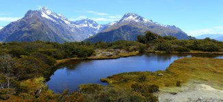
Routeburn Track 2AM 0796-0800 panorama. ©Andrew McInnes


Hiking (“tramping” in NZ) up to Key Summit.

Routeburn Track 2AM-000788

Routeburn Track 2AM-000788. ©Andrew McInnes


A loo with a view – sort of.

Routeburn Track 2AM-000814

Routeburn Track 2AM-000814. ©Andrew McInnes


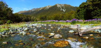
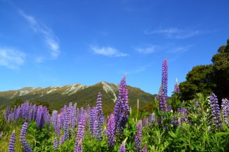
Driving into Fiordland National Park in the morning we noticed a field of lupins and thought that it would be worth a look on the way out that evening. What a beautiful scene it turned out to be!

This is Cascade Creek, along the Te Anau-Milford Hwy.

Cascade Creek 2AM 0827-0832 Pano

Cascade Creek 2AM 0827-0832 Panorama. ©Andrew McInnes

Cascade Creek 2AM 0842-0843 pano

Cascade Creek 2AM 0842-0843 panorama. ©Andrew McInnes

Cascade Creek 2AM-000819

Cascade Creek 2AM-000819. ©Andrew McInnes

Cascade Creek 2AM-000844

Cascade Creek 2AM-000844. ©Andrew McInnes

Cascade Creek 2AM-000863

Cascade Creek 2AM-000863. ©Andrew McInnes

Cascade Creek 2AM-000865

Cascade Creek 2AM-000865. ©Andrew McInnes

Cascade Creek 2AM-000889

Cascade Creek 2AM-000889. ©Andrew McInnes

Cascade Creek 2AM-000835

Cascade Creek 2AM-000835. ©Andrew McInnes

Cascade Creek 2AM-000818

Cascade Creek 2AM-000818. ©Andrew McInnes

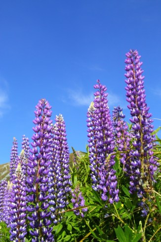
I hope you like lupins 😉
Thanks for viewing my images.

Cheers 🙂

Posting #7 of my road trip from Fremantle to Kununurra, Western Australia.

Ah, I arrived at my destination – Kununurra – after 9 days of driving and bush camping. Here are some images around the greater Kununurra area from the first day or so.

Not far short of Kununurra, and the scenery, topography, and geology changes (after leaving Halls Creek).

Highway-and-Bluff-2AM-003678

Great Northern Highway 2AM-003678. © 2014 Andrew McInnes.

Assorted roadside grasses…

Grass-2AM-002958

Grass 2AM-002958. © 2014 Andrew McInnes.

Grass-2AM-002960

Grass 2AM-002960. © 2014 Andrew McInnes.

Lake-Argyle-2AM-003141

Grass 2AM-003141. © 2014 Andrew McInnes.

The fishing is fantastic in the Kimberley; this is a 1.14 meter Barramundi (released immediately after photo) caught on the lower Ord River.

Duane-and-Barramundi-2AM_3066_b

Fisherman and Barramundi 2AM-3066. © 2014 Andrew McInnes.

The ubiquitous estaurine crocodiles (“Saltwater Crocodile”) necessitate care around the water.

Saltwater-Crocodile-2AM-004748---Copy

Saltwater Crocodile 2AM-004748. © 2014 Andrew McInnes.

Saltwater-Crocodile-2AM-004757

Saltwater Crocodile 2AM-004757. © 2014 Andrew McInnes.

Saltwater-Crocodile-2AM-004771

Saltwater Crocodile 2AM-004771. © 2014 Andrew McInnes.


Iconic Kimberley vistas…
If you have watched the movie “Australia” then you may recognise this geologic feature, known as ‘House Roof Hill’ – it is the backdrop to the fictional “Faraway Downs” homestead.
This image was captured very early on another glorious Kimberley morning.

House-Roof-Hill-2AM-003047

House Roof Hill 2AM-003047. © 2014 Andrew McInnes.

The next image is “False House Roof Hill” – neighboring bluffs along the Ord River.

False-House-Roof-Hill-2AM-003013

False House Roof Hill 2AM-003013. © 2014 Andrew McInnes.

The April 2014 Lunar Eclipse occurred whilst I was in this area. The following image captures part of this eclipse over a Kimberley range.

Lunar-Eclipse-2AM-004793

Lunar Eclipse 2AM-004793. © 2014 Andrew McInnes.

Lake Argyle is Australia’s largest artificial lake (by volume). It is part of the Ord River Irrigation Scheme and is a sight to behold. Unfortunately these “roadside” images are all I managed to capture of this vast and beautiful feature – I must return and spend time above and on the lake!

Lake-Argyle-2AM-3131-3134-pano

Lake Argyle 2AM_3131-3134 panoramic. © 2014 Andrew McInnes.

An alternate view of the Ord River Dam – construction was completed in 1971.

Lake-Argyle-2AM-003126

Lake Argyle 2AM-003126. © 2014 Andrew McInnes.

Grass in seed along the dam wall – beautiful April conditions.

Lake-Argyle-2AM-003137

Lake Argyle 2AM-003137. © 2014 Andrew McInnes.