Skeins of yarn at The Yarn Bowl, Banyo, Queensland.
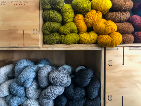
Yarn-2AM-000770 ©Andrew McInnes
Yarn-2AM-000771 ©Andrew McInnes
Cheers 🙂
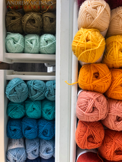
Skeins of yarn at The Yarn Bowl, Banyo, Queensland.
Yarn-2AM-000770 ©Andrew McInnes
Yarn-2AM-000771 ©Andrew McInnes
Cheers 🙂
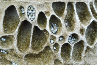
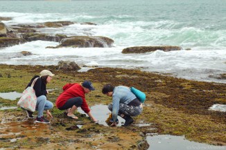
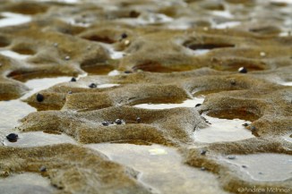
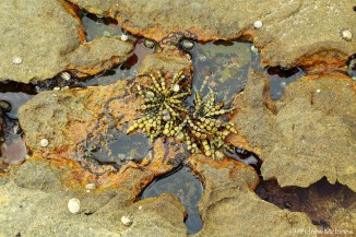
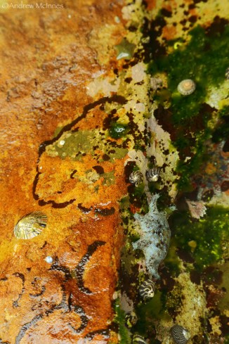
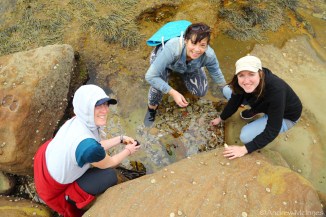
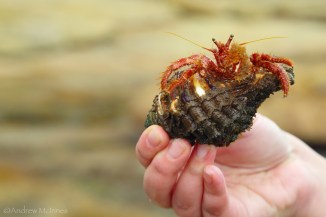
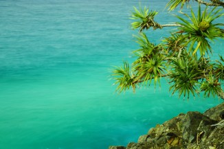
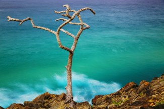
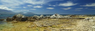
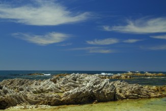
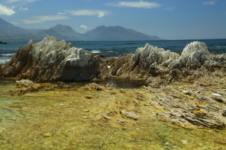
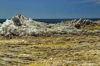
An assortment of subjects from the intertidal zone at Pearl Beach, NSW.

Pearl Beach 2AM-008782
Pearl Beach 2AM-008788
Pearl Beach 2AM-008793

Pearl Beach 2AM-008798
Pearl Beach 2AM-008803

Pearl Beach 2AM-008816

Pearl Beach 2AM-008830
Pearl Beach 2AM-008835
Pearl Beach 2AM-008844
Pearl Beach 2AM-008849

Pearl Beach 2AM-008857
Pearl Beach 2AM-008864

Pearl Beach 2AM-008871
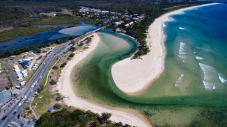
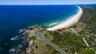
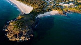
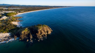
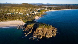
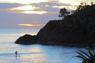
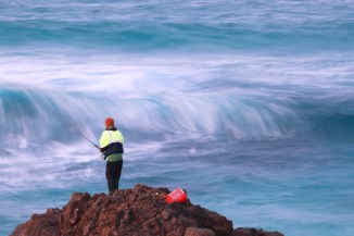
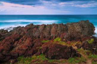
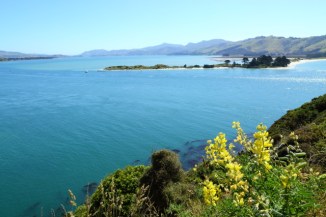
Aerial and terrestrial images of Cabarita Beach, Norries Head, Hastings Point, and Cudgera Creek – on the Tweed Coast of NSW.

Cabarita Beach 2AM-000274

Fish 2AM-007879
Hastings Point, NSW – where Cudgera Creek enters the sea after it’s sinuous meander.
Hastings Point 2AM-000277
Hastings Point 2AM-000278

Hastings Point 2AM-000281

Hastings Point 2AM-000289

Hastings Point 2AM-000292
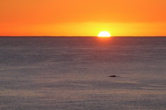
Humpback Sunrise 2AM-007774

Maggies Beach 2AM 3413-3414 Panorama

Norries Head 2AM-000265

Norries Head 2AM 262-263 Panorama
Norries Head 2AM-000266
Norries Head 2AM-000270
Norries Head 2AM-000271
Norries Head 2AM-007865

Norries Head 2AM-007869
Cabarita Beach 2AM-008398
Hastings Point 2AM-002294

Hastings Point 2AM-008417
Hastings Point 2AM-008447

Norries Head 2AM-002279
Norries Head 2AM-008392
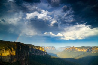
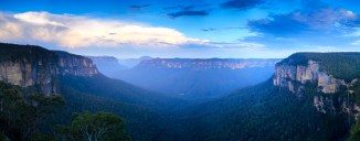
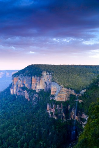
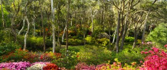
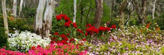
Rain caresses the skirts of Grose Valley in the Blue Mountains – near Blackheath, NSW, plus a portion of the floral diversity at the beautiful Campbell Rhododendron Gardens in Blackheath, NSW.

Blue Mountains 2AM-006879
Blue Mountains 2AM-006899

Blue Mountains 2AM 6914-6915 Panorama
Blue Mountains 2AM 6929-6935 Panorama

Blue Mountains 2AM-006938
Blue Mountains 2AM-006942
Campbell Rhododendron Gardens 2AM 6831-6832 Panorama
Campbell Rhododendron Gardens 2AM 6845-6847 Panorama
Day 9-11. Makarora and Fox Glacier etc, South Island – New Zealand.
Onwards…
More from Otago, plus some from West Coast. As is the case with all holidays, the end comes too soon.
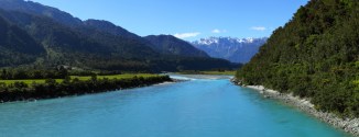
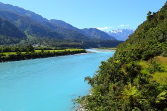
This last post includes images from Blue Pools on the Makarora River, the Whataroa River, Fox Glacier, and Lake Hawea (near The Neck).
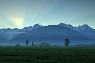
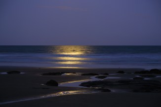
Dusk settles over the Southern Alps at Makarora.

Makarora 2AM-000934.
©Andrew McInnes
Makarora River 2AM-000931.
©Andrew McInnes

Makarora River 2AM-000930.
©Andrew McInnes
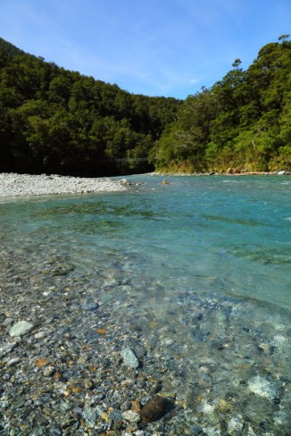
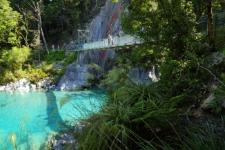
The stunning, and frigid, Blue Pools.

Blue Pools – Makarora River 2AM-000916.
©Andrew McInnes
Blue Pools – Makarora River 2AM-000914.
©Andrew McInnes
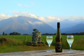
Happy hour 🙂
Cold beers and conversation in and alongside the Makarora River.

Makarora 2AM-000539.
©Andrew McInnes
A Tui (Prosthemadera novaeseelandiae), in the honeyeater family, foraging on New Zealand flax (Phormium sp.).

Tui 2AM-004945.
©Andrew McInnes
Dawn over the Southern Alps at Fox Glacier – includes Aoraki / Mount Cook.
Fox Glacier 2AM 1002-4 HDR.
©Andrew McInnes
Fox Glacier 2AM-000957. ©Andrew McInnes

Fox Glacier 2AM-000981.
©Andrew McInnes
Fox Glacier 2AM-000988.
©Andrew McInnes

Fox Glacier 2AM-000993.
©Andrew McInnes
Fox Glacier 2AM-000995.
©Andrew McInnes

The Neck 2AM-000537 iPhone panorama.
©Andrew McInnes
Whataroa River 2AM 1024-1029 panorama.
©Andrew McInnes
Whataroa River 2AM-001017.
©Andrew McInnes
I hope you enjoyed this and the previous posts of my images from a fantastic holiday in New Zealand.
Cheers 🙂
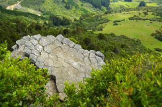
Ah, to have more time to explore and be awed by Fiordland National Park! And a revisit in late winter/early spring is in order too.
We ventured along the Te Anau – Milford Highway, to hike the Key Summit, a day-hike portion of the Routeburn Track, beginning at The Divide. Spectacular!
Here is a portion of the view from the end of Key Summit.
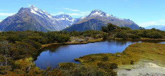
Routeburn Track 2AM 0796-0800 panorama. ©Andrew McInnes
Hiking (“tramping” in NZ) up to Key Summit.

Routeburn Track 2AM-000788. ©Andrew McInnes
A loo with a view – sort of.

Routeburn Track 2AM-000814. ©Andrew McInnes
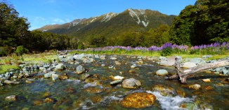
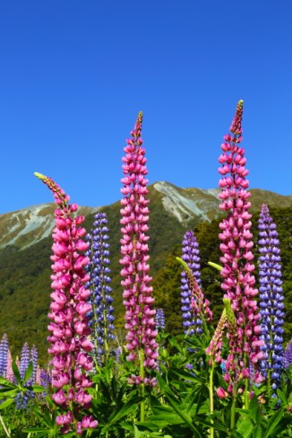
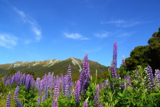
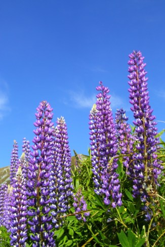
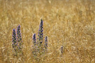
Driving into Fiordland National Park in the morning we noticed a field of lupins and thought that it would be worth a look on the way out that evening. What a beautiful scene it turned out to be!
This is Cascade Creek, along the Te Anau-Milford Hwy.

Cascade Creek 2AM 0827-0832 Panorama. ©Andrew McInnes
Cascade Creek 2AM 0842-0843 panorama. ©Andrew McInnes
Cascade Creek 2AM-000819. ©Andrew McInnes

Cascade Creek 2AM-000844. ©Andrew McInnes
Cascade Creek 2AM-000863. ©Andrew McInnes
Cascade Creek 2AM-000865. ©Andrew McInnes

Cascade Creek 2AM-000889. ©Andrew McInnes

Cascade Creek 2AM-000835. ©Andrew McInnes

Cascade Creek 2AM-000818. ©Andrew McInnes
I hope you like lupins 😉
Thanks for viewing my images.
Cheers 🙂
Day 7 – The spectacular Catlins area, South Island – New Zealand.
Spectacular, diverse, ever-changing – we drove through beautiful rural scenes, along a rugged coast, saw a few more yellow-eyed penguins, sea lions, a couple of lighthouses, and low tide allowed us to walk among a 180 million year old petrified Jurassic forest – one of only three such accessible fossil forests in the world! All this and so much more we couldn’t fit in 😦
Nugget Point Lighthouse, built in 1869-70. A place of spectacular views, many rocky islets (The Nuggets), and much wildlife.
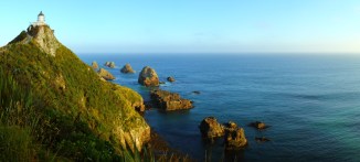
Nugget Point Lighthouse 2AM-0379-0744 panorama. ©Andrew McInnes
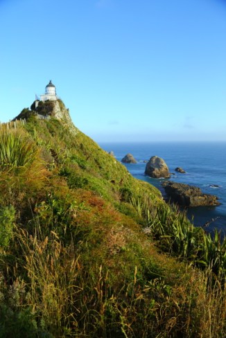
Nugget Point Lighthouse 2AM-000749. ©Andrew McInnes

Nugget Point Lighthouse 2AM-000754. ©Andrew McInnes

Nugget Point Lighthouse 2AM-000775. ©Andrew McInnes
To be able to view, and even walk among a petrified forest in the intertidal zone at low tide was remarkable. There are both stumps and fallen trees, petrified, with some growth rings plainly visible. This is but a sampling of the numerous specimens at Curio Bay.
Curio Bay is of international significance for its fossilised forest dating back to the Jurassic period. The tree fossils you see here are 160 million years old and the forest was alive when New Zealand was part of Gondwanaland. (source: The Catlins New Zealand website).

Petrified Forest – Curio Bay 2AM-000635. ©Andrew McInnes

Petrified Forest – Curio Bay 2AM-000631. ©Andrew McInnes

Petrified Forest – Curio Bay 2AM-000634. ©Andrew McInnes

Petrified Forest – Curio Bay 2AM-000665. ©Andrew McInnes

Petrified Forest – Curio Bay 2AM-000656. ©Andrew McInnes
Four images of the Waipapa Point Lighthouse. This is the site of New Zealand’s worst civilian shipwreck. In 1881 the SS Tararua ran aground on Waipapa Reef and 131 of 151 passengers and crew died. The lighthouse, built after the disaster, stands as a poignant reminder. (source: Southern Scenic Route website).

Waipapa Point Lighthouse 2AM-000600. ©Andrew McInnes

Waipapa Point Lighthouse 2AM-000611. ©Andrew McInnes

Waipapa Point Lighthouse 2AM-000622. ©Andrew McInnes

Waipapa Point Lighthouse 2AM-000616. ©Andrew McInnes
I hope you enjoyed these images from a fascinating region of New Zealand.
Cheers 🙂
Days 5 and 6 – Moeraki and Dunedin.
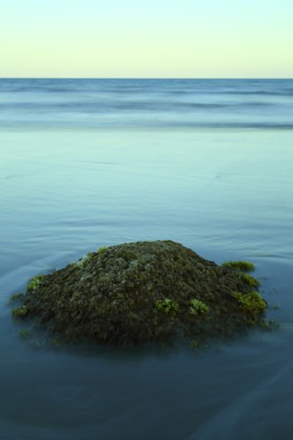
Just outside the coastal town of Moeraki there are numerous large concretions, exposed and highly visible, lying along a stretch of Koekohe Beach. I thoroughly recommend reading more about them (here is a Wikipedia link).
Here are a series of images captured during our brief visit.
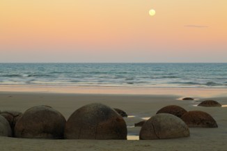
Moeraki Boulders 2AM-000526. ©Andrew McInnes

Moeraki Boulders 2AM-000500. ©Andrew McInnes

Moeraki Boulders 2AM-000496. ©Andrew McInnes
Moeraki Boulders 2AM-000517. ©Andrew McInnes
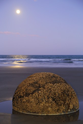
Moeraki Boulders 2AM-000533. ©Andrew McInnes

Moeraki Boulders 2AM-000549. ©Andrew McInnes
Moeraki Boulders 2AM-000538. ©Andrew McInnes
After a thoroughly enjoyable dinner washed down with a local amber ale at the Moeraki Tavern, I took these shots of the nearby harbour. We had hoped to also eat at the famed Fleurs Place restaurant another night but, alas, it was closed for a while over the Christmas break.
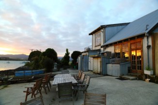
Fleurs Place – Restaurant 2AM-000598. ©Andrew McInnes

Moeraki Bay 2AM-000599. ©Andrew McInnes

Moeraki Bay 2AM-000593. ©Andrew McInnes

Moeraki Bay 2AM-000595. ©Andrew McInnes
A little further south is the city of Dunedin, where I have family heritage. We had a joyous visit with a cousin and her family, and she accompanied us on a lovely hike to see the Organ Pipes. “The Otago peninsula was formed entirely by volcanic activity and the tall polygonal columns featured on this walk are remnants of this past. As molten lava cooled slowly beneath the hardened crust, it contracted and formed geometrical cracks which propagated downwards as the mass cooled.” (source: NZ Tramper website).
The Organ Pipes 2AM-000567. ©Andrew McInnes

The Organ Pipes 2AM-000576. ©Andrew McInnes

The Organ Pipes 2AM-000577. ©Andrew McInnes

The Organ Pipes 2AM-000578. ©Andrew McInnes
After the organ pipes we wanted to visit the world’s only mainland breeding colony of Royal Albatross so we ventured out to Taiaroa Head on the Otago Peninsula. Unfortunately we did not see any albatross, but there was a rather active colony of gulls. Whilst wandering along an observation path, we heard, then saw, quite an aerial commotion… upon further observation we saw a Black-backed Gull being harassed by several smaller gulls – the larger gull had apparently “kidnapped” a chick and was heading off with it. For those who may be a bit squeamish about natural history, the following two images may concern you.

Black-backed Gull 2AM-004861. ©Andrew McInnes

Black-backed Gull 2AM-004882. ©Andrew McInnes
Looking down the steep cliffs of Taiaroa Head I was entranced by bull kelp (Durvillaea species) as it seemingly twirled and shimmied in a whimsical tango with the ocean.

Overlooking the spit within Otago Harbour – our lunch spot on our way back to Moeraki.
Harrington Point 2AM-000580. ©Andrew McInnes
Back to Mouraki, we were thrilled and fortunate to observe, up close, a few Yellow-eyed Penguins (Megadyptes antipodes)! These New Zealand endemics (native) are purported to be among the worlds rarest penguin species.

Yellow-eyed Penguin 2AM-004739. ©Andrew McInnes
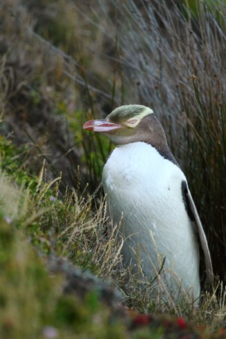
Yellow-eyed Penguin 2AM-004780. ©Andrew McInnes
Thanks for visiting – I hope you enjoyed these images.
Cheers 🙂
This post covers three days (day 2, 3, and 4) of our holiday in New Zealand. It involved driving from Rotorua (see previous post here) to Wellington then departing on the ferry at 2:30 am to Picton, arriving around dawn, then driving to Kaikoura.
Day 2-4 – Heading to the South Island.
Unfortunately, as with all holidays, there is not enough time to see everything. There is a lot to see on the North Island but even though we had a loose schedule, there were some hard times/dates we needed to be at certain places – one such deadline was a ferry connection to take us to the South Island.
Leaving Rotorua we headed to Wellington via Lake Taupo and a few other smallish diversions. Whilst in the Rotorua area we visited Hamurana Springs for a peaceful and scenic break and saw this Waka (Māori watercraft).

Waka – Hamurana Springs 2AM-000456. ©Andrew McInnes
Because I like birds…
A Paradise Shelduck on the shore of Lake Taupo.

Paradise Shelduck 2AM-004285. ©Andrew McInnes
South of the beautiful Lake Taupo area are some volcanic features many of you may recognise from the The Lord of the Rings film trilogy. The “Desert Road” through Rangipo Desert is a spectacular drive, and we paused for lunch with this view of Mount Ruapehu (left) and Mount Ngauruhoe (right) – the fictional Mount Doom. iPhone 5C panorama.

Tongariro National Park 2AM-000471. ©Andrew McInnes
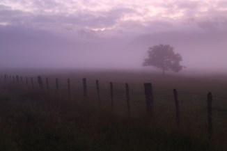
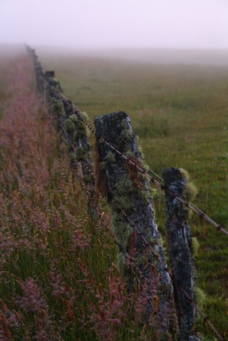
Further south, a fence that caught my eye. iPhone 5C photo.

Waituna West 2AM-000474. ©Andrew McInnes
Onto the South Island.
Kaikoura and surrounds – abundant marine mammals, beautiful scenes.
I reckon these folks have a fantastic campsite!

Half Moon Bay – Kaikoura 2AM-000343. ©Andrew McInnes
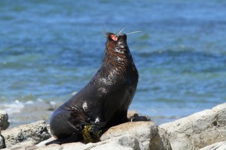
The seemingly ubiquitous New Zealand fur seal, basking, resting, and nursing the young at Ohau Point, Half Moon Bay (just north of Kaikoura).
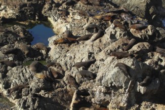
New Zealand fur seal 2AM-004332. ©Andrew McInnes
New Zealand fur seal 2AM-004337. ©Andrew McInnes
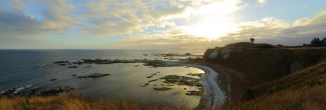
Kaikoura awaking with the dawn.
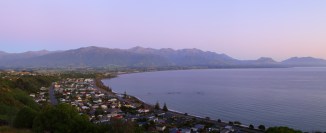
Kaikoura 2AM 0407-0409 Panorama. ©Andrew McInnes
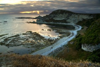
Dusk settles over the Kaikoura Peninsula.
Kaikoura Peninsula 2AM 0348-0351 Panorama. ©Andrew McInnes

Kaikoura Peninsula 2AM 0356-0358 HDR. ©Andrew McInnes
Kaikoura Peninsula 2AM 0365-0367 HDR. ©Andrew McInnes
Kaikoura Peninsula 2AM 0374-0377 Panorama. ©Andrew McInnes
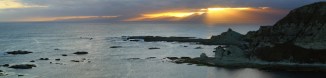
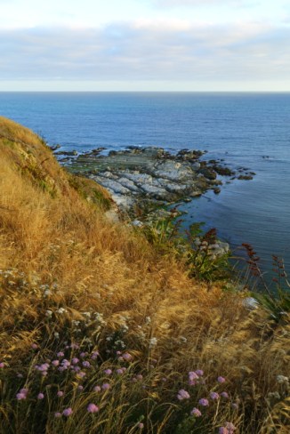
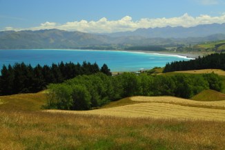
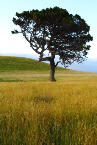
Assorted images from the wondrous Kaikoura Peninsula:
Kaikoura Peninsula 2AM-000353. ©Andrew McInnes

Kaikoura Peninsula 2AM-004506. ©Andrew McInnes
Kaikoura Peninsula 2AM-004498. ©Andrew McInnes
Kaikoura Peninsula 2AM-000484. ©Andrew McInnes

Kaikoura Peninsula 2AM-000482. ©Andrew McInnes
Kaikoura Peninsula 2AM-000355. ©Andrew McInnes

Wooden Fence 2AM-004690. ©Andrew McInnes
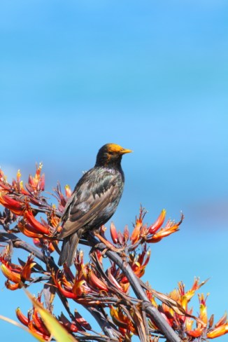
European Starling 2AM-004447. ©Andrew McInnes
In case any so-called birders or twitchers are wondering, this isn’t a new plumage for this species. Rather, it is pollen from the prolific pollen-producing plant, the New Zealand flax (Phormium).
Rhyolitic flows (I think so, at least) at Kaikoura.
Kaikoura Peninsula 2AM 0458-0460 Panorama. ©Andrew McInnes
Kaikoura Peninsula 2AM-000455. ©Andrew McInnes

Kaikoura Peninsula 2AM-000456. ©Andrew McInnes
Kaikoura Peninsula 2AM-000461. ©Andrew McInnes
Kaikoura Peninsula 2AM-000462. ©Andrew McInnes
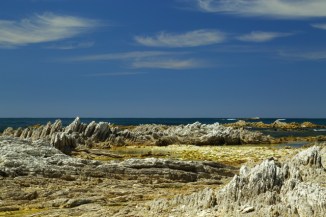
Kaikoura Peninsula 2AM-000463. ©Andrew McInnes
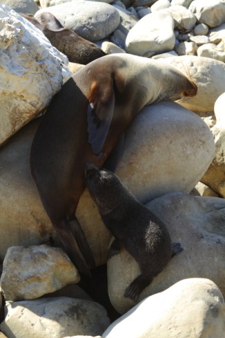
To wrap up this post, here are some more images of New Zealand fur seals 🙂
This time from the Kaikoura Peninsula.

New Zealand fur seal 2AM-004384. ©Andrew McInnes
New Zealand fur seal 2AM-004403. ©Andrew McInnes

New Zealand fur seal 2AM-004426. ©Andrew McInnes
I hope you enjoyed these.
Cheers 🙂
