A few beach and intertidal images from Iluka, NSW.

An assortment of subjects from the beach and intertidal zones near Iluka, NSW.

A winding path with a turn back – a gastropod trail in the sand.

Beach Tracks 2AM-007195

Beach Tracks 2AM-007195 © Andrew McInnes

Iluka Dawn 2AM-007196

Iluka Dawn 2AM-007196 © Andrew McInnes

Dawn Fishing 2AM-009847

Dawn Fishing 2AM-009847 © Andrew McInnes

Ghost Crab 2AM-009873

Ghost Crab 2AM-009873 © Andrew McInnes

Kelp - Intertidal rock pool 2AM-007210

Ecklonia radiata – kelp 2AM-007210 © Andrew McInnes

Neptune's Necklace 2AM-007209

Neptune’s Necklace 2AM-007209 © Andrew McInnes

Cheers.

Empress Falls in the Blue Mountains, NSW.

Empress Falls is a stunning waterfall near the town of Wentworth Falls in the Blue Mountains of NSW, Australia. The Valley of the Waters Creek pours over fern-fringed ledges as Empress Falls, a 30 metre fall into a cold deep pool.

The hike in and out from The Conservation Hut is slightly vigorous (about 30 minutes hike each way), yet absolutely worth it if you are hesitant, especially if you like waterfalls.

This image shows the final section of descent to the bottom of the waterfall.

Empress Falls 2AM-009335

Empress Falls 2AM-009335 © Andrew McInnes


On the lower section of the bushwalk there are numerous seeps and soaks, especially if there has been recent rains.

Empress Falls 2AM-009339

Empress Falls 2AM-009339 © Andrew McInnes


Abseiling (rappelling) is very popular and the Blue Mountains Adventure Company can provide the experience for you.

Empress Falls 2AM-009348

Empress Falls 2AM-009348 © Andrew McInnes


A little further downstream of Empress Falls are a series of smaller, but no less beautiful waterfalls such as the following image of Sylvia Falls.

Empress Falls 2AM-009358

Sylvia Falls 2AM-009358 © Andrew McInnes

Cheers.


Minnamurra Rainforest

These images capture a portion of a remnant pocket of subtropical and warm temperate rainforest that is the Minnamurra Forest – within Budderoo National Park near Jamberoo and Kiama, NSW.

Minnamurra Rainforest 2AM 7191-3_HDR

Minnamurra Rainforest 2AM 7191-7193_HDR © Andrew McInnes

Australian water dragon 2AM-009846

Australian water dragon 2AM-009846 © Andrew McInnes

Minnamurra Falls 2AM-007179

Minnamurra Falls 2AM-007179 © Andrew McInnes

Minnamurra Falls 2AM-007183

Minnamurra Falls 2AM-007183 © Andrew McInnes

Minnamurra Rainforest 2AM-007145

Minnamurra Rainforest 2AM-007145 © Andrew McInnes

Minnamurra Rainforest 2AM-007154

Minnamurra Rainforest 2AM-007154 © Andrew McInnes

Minnamurra Rainforest 2AM-007161

Minnamurra Rainforest 2AM-007161 © Andrew McInnes

Minnamurra Rainforest 2AM-009815

Minnamurra Rainforest 2AM-009815 © Andrew McInnes

Minnamurra Rainforest 2AM-009818

Minnamurra Rainforest 2AM-009818 © Andrew McInnes

Minnamurra Rainforest 2AM-009821

Minnamurra Rainforest 2AM-009821 © Andrew McInnes

Minnamurra Rainforest 2AM-009822

Minnamurra Rainforest 2AM-009822 © Andrew McInnes

Minnamurra Rainforest 2AM-009825

Minnamurra Rainforest 2AM-009825 © Andrew McInnes


Cheers 🙂

Springsure, Queensland – including a light-painting episode.

This is overlooking Virgin Rock and the town of Springsure in the Central Highlands Region of Queensland, Australia – as seen from Minerva Hills National Park. As is my want, I hiked in a few hours too early with all the required equipment and froze my bum off, waiting for dusk’s blue hour and the town lights to be on, in order to light-paint this scene…

This is the “before” image, taken on iPhone 5:

Springsure 2AM-000137 © Andrew McInnes


And this is the subsequent light-painting image.

Springsure 2AM 8300-8301 HDR

Springsure 2AM 8300-8301 stack © Andrew McInnes


The remaining images here are different views of Mount Zamia escarpment, incorporating Virgin Rock:

Longreach trip_2015

Springsure 2AM 8353-8355 Panorama © Andrew McInnes


This is a light-painting of the entrance to Springsure Golf Club.

Springsure 2AM-008319

Springsure 2AM-008319 © Andrew McInnes


For the following shots it was 1 degree C, and silly me, I was out photographing in thongs (i.e. Flip flops, not the underwear variety), light summer fishing pants, t-shirt and an old hoodie! Brrr.
On the left is Virgin Rock – a feature of the Mount Zamia escarpment.

The following two images are essentially very similar compositions, but were taken  50 minutes apart.
different light = different feel.

Springsure 2AM-008332

Springsure 2AM-008332 © Andrew McInnes

Springsure 2AM-008359

Springsure 2AM-008359 © Andrew McInnes


Hope you enjoyed a brief glimpse of this beautiful area of Queensland.

Cheers.


Nullarbor/Bunda Cliffs – South Australia

A spectacular stop along the Nullarbor Plain and Eyre Peninsula in the very western parts of South Australia- we rested here for a night and enjoyed being surrounded by lightning storms and their associated thumping thunder.

Nullarbor-Cliffs-2AM-6514-6517-Panorama

Nullarbor Cliffs 2AM 6514-6517 Panorama © Andrew McInnes. All Rights Reserved.

Nullarbor-Cliffs-2AM-6526and6529copyand6543copy

Nullarbor Cliffs 2AM 6526and6529and6543 stack. © Andrew McInnes. All Rights Reserved.

Nullarbor-Cliffs-2AM-006542---Copy_crop

Nullarbor Cliffs 2AM-006542 © Andrew McInnes. All Rights Reserved.

Nullarbor Cliffs 2AM-006502

Nullarbor Cliffs 2AM-006502 © Andrew McInnes. All Rights Reserved.

Nullarbor-Cliffs-2AM-006487

Nullarbor Cliffs 2AM-006487 © Andrew McInnes. All Rights Reserved.

Nullarbor-Cliffs-2AM-006492

Nullarbor Cliffs 2AM-006492 © Andrew McInnes. All Rights Reserved.

Nullarbor Cliffs 2AM-006495

Nullarbor Cliffs 2AM-006495 © Andrew McInnes. All Rights Reserved.


Posting #10 of my road trip from Fremantle to Kununurra, Western Australia.

A collection of images from Lake Kununurra, Lily Creek Lagoon, Ivanhoe Crossing, and the iconic Cockburn Ranges – all proximal to Kununurra, Western Australia.

A delightful boat ride up Lake Kununurra – the dog enjoyed the trip, especially the breeze in its face.

Lake Kununurra 2AM-003377. © 2014 Andrew McInnes.

Lake Kununurra 2AM-003403. © 2014 Andrew McInnes.

Lake Kununurra 2AM-003421. © 2014 Andrew McInnes.

Lake-Kununurra-2AM-003422

Lake Kununurra 2AM-003422. © 2014 Andrew McInnes.

A couple of the numerous and delightful inlets along the way.

Lake Kununurra 2AM-003425. © 2014 Andrew McInnes.

Lake Kununurra 2AM-003435. © 2014 Andrew McInnes.

The exposed geology is fascinating and stunning.

Lake Kununurra 2AM-003437. © 2014 Andrew McInnes.

The Kimberley region has numerous sites with indigenous rock art; this particular location is very near to Kununurra.

Aboriginal Rock Art 2AM-003475. © 2014 Andrew McInnes.

Aboriginal Rock Art 2AM-003480. © 2014 Andrew McInnes.

Aboriginal Rock Art 2AM-003483. © 2014 Andrew McInnes.

Aboriginal Rock Art 2AM-003485. © 2014 Andrew McInnes.

Aboriginal Rock Art 2AM-003487. © 2014 Andrew McInnes.

The view from the boat ramp on Lily Creek where we began and concluded this trip up Lake Kununurra.

Lily Creek Lagoon 2AM-003504. © 2014 Andrew McInnes.

Lily Creek Lagoon with ‘Sleeping Buddha’ in the background.

Lily Creek Lagoon 2AM-003502. © 2014 Andrew McInnes.

Off on a road trip now, just outside of Kununurra…

Highway Outcrop 2AM-003088. © 2014 Andrew McInnes.

Highway Outcrop 2AM-003079-003082 panorama © 2014 Andrew McInnes.

A couple of images of vehicles crossing a small creek on El Questro where we stopped off for a refreshing dip (swim).

El Questro 2AM-003308. © 2014 Andrew McInnes.

El Questro 2AM-003319. © 2014 Andrew McInnes.

Not far past El Questro, on the famed Gibb River Road, is the Cockburn Range which is adjacent to the iconic Pentecost River but the river was flowing too much for us to make a crossing. There was an unfortunate couple stranded during their attempt at crossing – their front axle fell into a deeply eroded hole resulting in a cracked oil-pan or something similar, necessitating a tow out of these croc-infested waters.

Cockburn Ranges 2AM-003366-003368 panorama. © 2014 Andrew McInnes.

Having captured this late-afternoon image of a man fishing for barramundi with a live bait on a hand line at the fast-flowing Ivanhoe Crossing, Kununurra, I moved on to shoot other nearby compositions. This area is accessible for the numerous salties of the Ord River and is also thick with barramundi. Soon after I moved I saw this fisherman in a mighty tug-of-war battle that, with the aid of the deep and rapidly flowing water, soon had him precariously close to taking an involuntary bath! Ultimately he was saved the ignominy as his large gauge hook was straightened, thus losing whatever was on the end of the line!
The Ivanhoe Crossing is no longer open to vehicles.

Ivanhoe Crossing 2AM-003178. © 2014 Andrew McInnes.


The next blog posting will contain images from Marlgu Billabong and Wyndham.
Until then, cheers.


Posting #9 of my road trip from Fremantle to Kununurra, Western Australia.

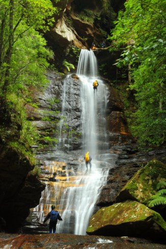
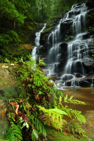
Other than the first two images, this post contains only aerial views of the Kununurra area, captured from a Robinson R22 helicopter owned and operated by Top End Mustering.

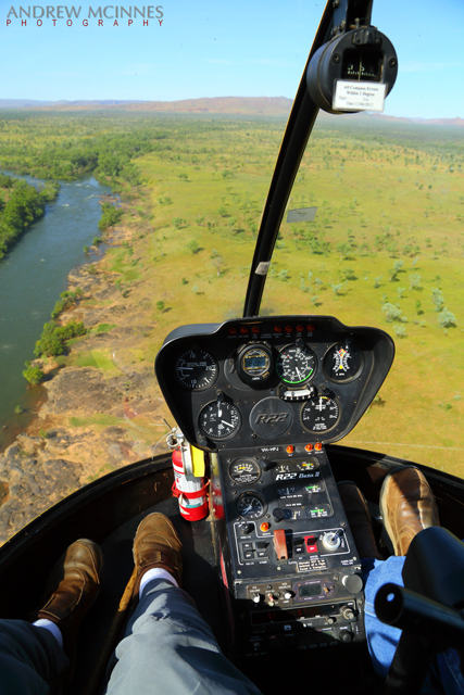
This is the helicopter for the trip, and the pilot – Ty Rankin (of Top End Mustering).

Helicopter-and-Pilot-2AM-003668

Helicopter and Pilot 2AM-003668. © 2014 Andrew McInnes.

Helicopter-2AM-003669

Helicopter 2AM-003669. © 2014 Andrew McInnes.

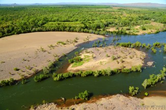
The Kimberley savannah and a portion of the lower Ord River – Ivanhoe Station.

Helicopter-and-Ord-River-2AM-003625

Helicopter-and-Ord-River-2AM-003625. © 2014 Andrew McInnes.

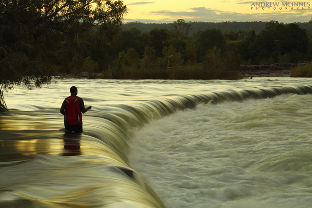
Below the dam of Lake Argyle, the Ord River Diversion Dam holds back Lake Kununurra, which gravity feeds the Ord River Irrigation Area with water via the Main Channel. The Victoria Highway crosses the river here.

Ord-River-Diversion-Dam-2AM-003654

Ord River Diversion Dam 2AM-003654. © 2014 Andrew McInnes.

Downstream of the Ord River Diversion Dam; the lowest reaches of Lake Kununurra meander to the upper left of the image, then beyond.

Ord-River-Diversion-Dam-2AM-003638

Ord River Diversion Dam 2AM-003638. © 2014 Andrew McInnes.

River flow below the Diversion Dam.

Ord-River-2AM-003616

Ord River 2AM-003616. © 2014 Andrew McInnes.

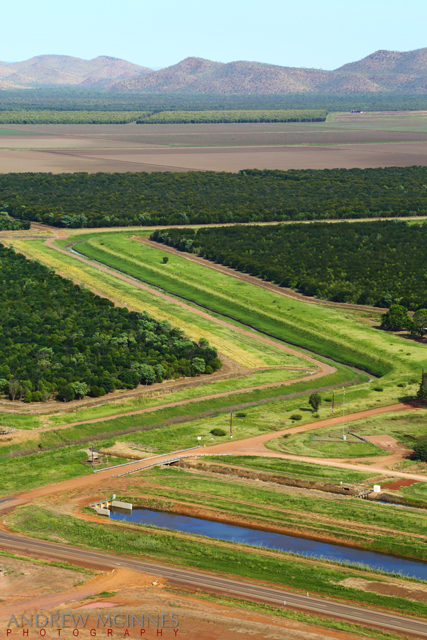
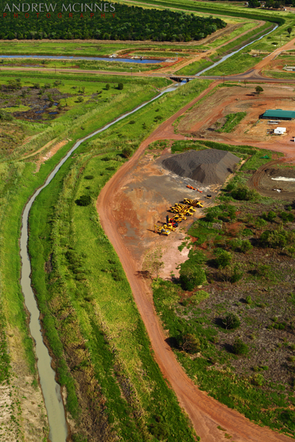
These next few images capture some of the irrigation ditches and the agriculture that depends on them.

Ord-River-Irrigation-Area-2AM-003541

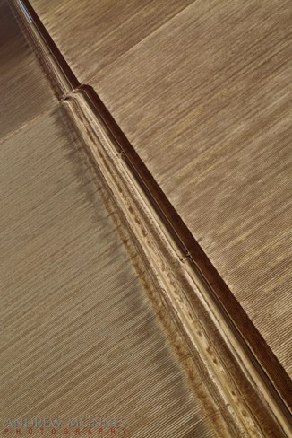
Ord River Irrigation Area 2AM-003541. © 2014 Andrew McInnes.

Ord-River-Irrigation-Area-2AM-003567

Ord River Irrigation Area 2AM-003567. © 2014 Andrew McInnes.

Though a variety of crops are present (and others tried previously), these are Indian Sandalwood.

Ord-River-Irrigation-Area-2AM-003555

Ord River Irrigation Area 2AM-003555. © 2014 Andrew McInnes.

Ord-River-Irrigation-Area-2AM-003554

Ord River Irrigation Area 2AM-003554. © 2014 Andrew McInnes.

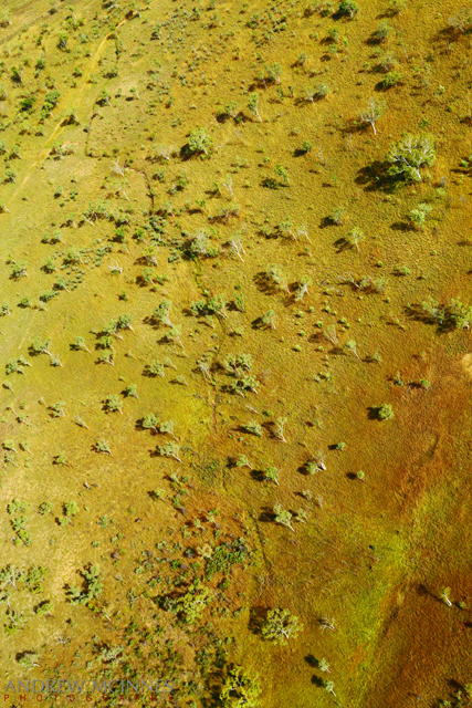
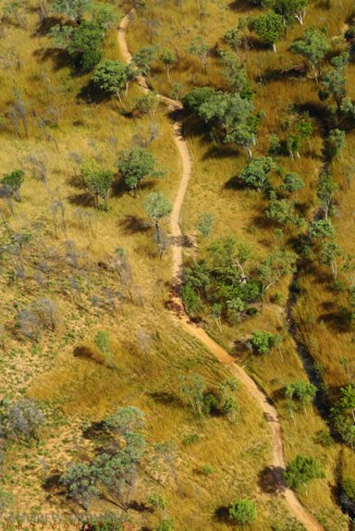
Great cattle stations abound in the Kimberley, and this savannah, like those throughout the world, look resplendent after the rains.

Kimberley-Savanna-2AM-003535

Kimberley Savanna 2AM-003535. © 2014 Andrew McInnes.

Kimberley-Savanna-2AM-003528

Kimberley Savanna 2AM-003528. © 2014 Andrew McInnes.

Kununurra-2AM-003604

Kununurra 2AM-003604. © 2014 Andrew McInnes.

A pair of graves on a station near Kununurra – DEACON, Thomas, died 28.6.1905 (age 49) & DURACK Neil Joseph, died 28.11.1920 (drowned, age 30).

Gravestones---Ivanhoe-Station-2AM-003608

Gravestones – Ivanhoe Station 2AM-003608. © 2014 Andrew McInnes.

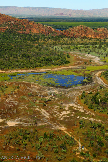
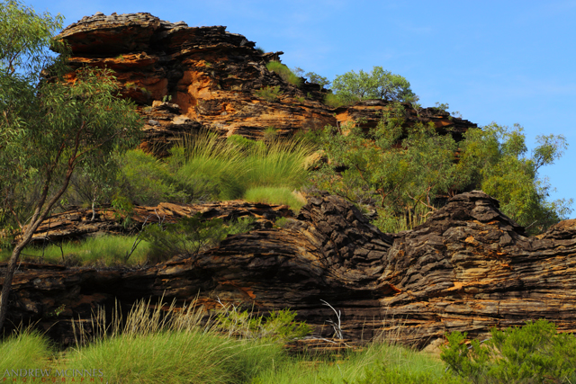
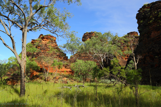
Bordering the irrigation area are numerous ranges such as this.

Kununurra-2AM-003530

Kununurra 2AM-003530. © 2014 Andrew McInnes.

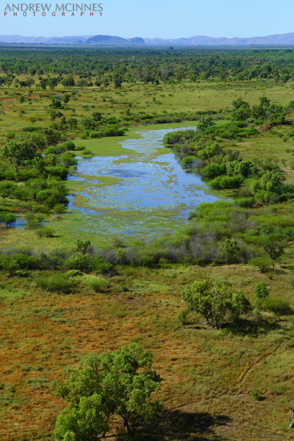
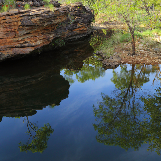
Edging and among the ranges there are numerous waterholes such as this, many with waterfalls (during/after the wet).

Kununurra-2AM-003597

Kununurra 2AM-003597. © 2014 Andrew McInnes.

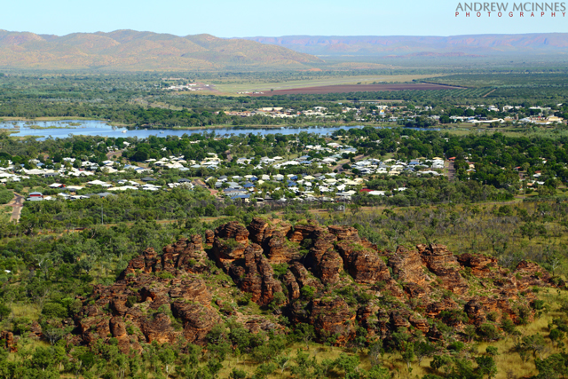
Back to the immediate vicinity of Kununurra: This is “Sleeping Buddha”/Elephant Rock on the edge of Lake Kununurra.

Sleeping-Buddha-2AM-003512

Sleeping Buddha 2AM-003512. © 2014 Andrew McInnes.

Sleeping-Buddha-floodplain-2AM-003517

Sleeping Buddha floodplain 2AM-003517. © 2014 Andrew McInnes.

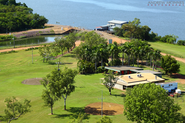
Two views of Lake Kununurra Golf Club – one of the hosts for famed the Ord Valley Muster.

Lake-Kununurra-Golf-Club-2AM-003662

Lake Kununurra Golf Club 2AM-003662. © 2014 Andrew McInnes.

Lake-Kununurra-Golf-Club-2AM-003664

Lake Kununurra Golf Club 2AM-003664. © 2014 Andrew McInnes.

The next post will feature Lake Kununurra – I hope you enjoyed this post.


Posting #8 of my road trip from Fremantle to Kununurra, Western Australia.

Mirima/Hidden Valley National Park – Kununurra, Western Australia.
Bungle Bungles in miniature – located just minutes from Kununurra, Mirima/Hidden Valley is a small park with sandstone ranges, cliffs and valleys, similar in appearance (and formed by similar processes) to parts of the Bungle Bungles (Purnululu National Park). The 350 million year old sandstone features within the park are subject to some striking colour changes due to sunlight variances.

Here is the ‘mini Bungle Bungles’ (a portion of Mirima/Hidden Valley), viewed from a helicopter, including the town of Kununurra, Lily Creek, Indian Sandalwood plantations, and a portion of the surrounding ranges.

Kununurra-and-Mini-Bungle-Bungles-2AM-003518

Kununurra and Mini Bungle Bungles 2AM-003518 © 2014 Andrew McInnes.

Hidden-Valley-National-Park-2AM-003519

Hidden Valley National Park 2AM-003519 © 2014 Andrew McInnes.

Hidden-Valley-National-Park-2AM-003533

Hidden-Valley-National-Park-2AM-003533. © 2014 Andrew McInnes.


Okay, back on terra firma – time for a wander through Hidden Valley…

Hidden-Valley-National-Park-2AM-003277

Hidden Valley National Park 2AM-003277. © 2014 Andrew McInnes.

Hidden-Valley-National-Park-2AM-003262

Hidden Valley National Park 2AM-003262. © 2014 Andrew McInnes.

Hidden-Valley-National-Park-2AM-003180

Hidden Valley National Park 2AM-003180. © 2014 Andrew McInnes.

Hidden-Valley-National-Park-2AM-003224

Hidden Valley National Park 2AM-003224. © 2014 Andrew McInnes.

Hidden-Valley-National-Park-2AM-003281

Hidden Valley National Park 2AM-003281. © 2014 Andrew McInnes.

Hidden-Valley-National-Park-2AM-003284

Hidden Valley National Park 2AM-003284. © 2014 Andrew McInnes.

Hidden-Valley-National-Park-2AM-003200

Hidden Valley National Park 2AM-003200. © 2014 Andrew McInnes.

Hidden-Valley-National-Park-2AM-003206_crop

Hidden Valley National Park 2AM-003206. © 2014 Andrew McInnes.

Hidden-Valley-National-Park-2AM-003249

Hidden Valley National Park 2AM-003249. © 2014 Andrew McInnes.

Hidden-Valley-National-Park-2AM-003259

Hidden Valley National Park 2AM-003259. © 2014 Andrew McInnes.

Hidden-Valley-National-Park-2AM-003273

Hidden Valley National Park 2AM-003273. © 2014 Andrew McInnes.

Red Posts at Sunset – Galveston, Texas.

Late yesterday afternoon the clouds parted allowing the post-front ‘northerly light’ to bath Galveston Island. I decided to drive around and see what the light suggested I photograph – my second, and last, stop was a beach the west end. A portion of clouds remained low on the western horizon painting a palette of pastels on this series of surprising red posts.


Red Posts - Galveston Island 2AM-001570-5D-Mark-III

Red Posts – Galveston Island 2AM-001570
Canon 5D Mark III with Canon 24-105mm f/4L lens. f22 for 20 seconds at ISO 50.
I also used two graduated N.D. filters (6 stops combined) as a regular N.D. filter to enable the long shutter speed.
© Andrew McInnes. All Rights Reserved.